July 2015 El Niño update: Bruce Lee?
El Niño continued to build during June, despite some shorter-term fluctuations in the climate system (here’s looking at you, MJO). CPC/IRI forecasters are still very confident that this event will persist through the winter, and they continue to favor a strong event, with the three-month average sea surface temperature in the Niño3.4 region expected to peak at more than 1.5°C above normal.
Nearly all the computer models are in agreement, and the atmosphere and ocean continued to behave in a very El Niño-like manner. So what is there to talk about this month? Well, a few interesting things happened over the past few weeks.
First, a quick rundown of where we find ourselves in the beginning of July
Sea surface temperatures (SSTs) all across the central and eastern equatorial Pacific were more than 1°C above normal, including a June average of 1.0-1.3°C (depending on SST dataset) above normal in the Niño3.4 region, our primary tracking indicator for ENSO events. The gradient in anomalies (anomaly = departure from long-term average) across the Pacific looks like a pretty classic El Niño event.

Sea surface temperature departure from normal, averaged 10 June – 1 July 2015. CPC figure.
Averaged over June, we continued to see more clouds and rain than normal over the central and eastern equatorial Pacific, fewer clouds and less rain over Indonesia, weaker near-surface easterly winds, and weaker upper-level westerly winds – all hallmarks of the reduced Walker Circulation characteristic of El Niño.
Which way does the wind blow?
The near-surface winds along the equatorial Pacific (the trade winds) are an important component of the ENSO system. These winds normally blow from east to west; they are usually persistent enough to sweep sun-warmed surface waters into a “pile” in the western Pacific. When they weaken, or even reverse (blowing from west to east), the warmer waters that are piled up in the western Pacific begin to move to the east. During El Niño, we expect these winds to be weaker than normal on monthly and seasonal timescales.
However, it’s normal for the background El Niño signal to be drowned out by short-lived weather patterns over one- or two-week periods. That was the case in the first half of June, when the weakened winds over the equatorial Pacific were temporarily amplified by an active Madden-Julian Oscillation (MJO).
The MJO is an area of enhanced convection and storms that travels around the world from west to east along the equator. Ahead and behind the active stormy area are areas of suppressed convection and drier conditions. The MJO affects near-surface wind patterns, because the rising air in the stormy area causes surface winds to blow toward the active area.

The surface and upper-atmosphere structure of the MJO for a period when the enhanced convective phase (thunderstorm cloud) is centered across the Indian Ocean and the suppressed convective phase is centered over the west-central Pacific Ocean. Horizontal arrows pointing left represent wind departures from average that are easterly, and arrows pointing right represent wind departures from average that are westerly. The entire system shifts eastward over time, eventually circling the globe and returning to its point of origin. Climate.gov drawing by Fiona Martin.
When the active area of the MJO is centered over the Indian Ocean and Indonesia, it leads to drier conditions and easterly trade winds over the tropical Pacific. (For a thorough description of the MJO and its interaction with ENSO, check out this post.)
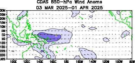
In the first half of June, the MJO was traveling through the Indian Ocean and Indonesia, which put an area of suppressed convection over the tropical Pacific. The related strengthening of the easterly trade winds and drier conditions over the Pacific temporarily weakened the atmospheric signal of El Niño conditions. (This is a good example of the short-term variations that Michelle discussed in her post couple of days ago.) But as soon as the MJO moved along, El Niño conditions strengthened again, and the monthly average conditions remained consistent with El Niño.

Difference from average near-surface winds in the tropical Pacific (120°E to 80°W). Each row in the plot is the daily average wind anomaly at 850 millibars from January (top) through early July 2015 (bottom). The stronger-than-average easterly winds caused by the MJO in early June first show up as a light blue area (circled). Over the next two weeks, the blue area moves east, sloping toward the bottom right of the image. For more on how to interpret these Hovmoller graphs, check out Tom’s post. CPC figure.
As I mentioned above, sometimes the easterly trade winds will weaken so much that they reverse, and blow from the west. A reversal of these winds tends to last only a week or two—an episode we call a westerly wind burst. Often, but not always, a westerly wind burst will kick off a downwelling Kelvin Wave, where a warmer-than-average pulse of subsurface waters travels east across the Pacific.
Two strong westerly wind bursts, in the first half of March and the first half of May, preceded the downwelling Kelvin waves during this spring and early summer, and as a result, contributed to the fairly impressive El Niño we see now.
During the end of June and first week of July, another very strong westerly wind burst occurred in the western Pacific, on the heels of the MJO event. It is likely that this westerly wind burst will reinforce the movement of warmer waters to the east, maintaining and probably strengthening this El Niño.

Near-surface wind average and departure from normal over the tropical Pacific, averaged from 29 June to 3 July 2015. CPC figure.
What’s in a name?
Tropical storms and hurricanes have been given names since the early 1950s, which helps to clarify communications. In recent years, the Weather Channel has attracted attention by naming winter storms, perhaps with similar intentions. “So why don’t we name ENSO events?” you ask. Excellent question! I propose we do name them, starting this year. Since I think we should have a theme to the names, and the theme should be action movie stars, I hereby designate the 2015-2016 event as El Niño Bruce Lee.

Statue of movie star and martial artist Bruce Lee on the Avenue of Stars of Hong Kong. Photo by Soerfm from Wikimedia.org.
Comments
Add new comment